I studied for a PhD (1995-1998) at Reading University Meteorology
Department with Professor Keith Browning, and continued to work
there for two years afterwards. A little of of what I did is covered
by this
page. There's much more detail in my thesis, "Radar observations of mixing within frontal
zones", though (and I'm really cursing myself as I write this!) I
messed up when archiving things, and have lost a few of the
diagrams. I may scan them from the printed version at some date...
Publications:
- Stacked slantwise convective circulations (2001)
Browning,
K. A., D. Chapman and R. S. Dixon,
Quart. J. Roy. Meteorol. Soc., 127, 2513-2536.
- Measurements of dissipation rate in frontal zones (2001)
Chapman, D., and K. A. Browning, Quart. J. Roy. Meteorol.
Soc., 127, 1939-1959.
- Weather observations from the Chilbolton Advanced
Meteorological Radar (2000)
Kilburn, C. A. D., D. Chapman, A. J.
Illingworth and R. J. Hogan, Weather, 55(10),352-355.
- Release of potential shearing instability in warm frontal
zones (1999)
Chapman, D., and K. A. Browning, Quart J. Roy.
Meteorol. Soc., 125(558B), 2265-2289.
- Use of wind-shear displays for Doppler radar data (1998)
Chapman, D., and K. A. Browning, Bull. Am. Meteorol. Soc.,
79(12), 2685-2691.
- First radar detection of a misocyclone in a UK tornadic
storm (1998)
Chapman, D., N. M. Roberts, A. J. Illingworth and K. A.
Browning, Weather, 53, 367-368.
- Radar observations of wind-shear splitting within evolving
atmospheric Kelvin-Helmholtz billows (1997)
Chapman, D., and K. A.
Browning, Quart J. Roy. Meteorol. Soc.,
123(541A), 1433-1439.
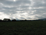
Here are some photos (click to get full-size images) I took of clouds perturbed by Kelvin-Helmholtz waves on 5 Nov 2006 on the Isle of Wight. My estimate of the wavelength is approx 1km, but I'm really not sure. It might be possible to estimate by tracking the movement of features in the photos and using the timestamp embedded in the images.


Back home


